MARS RECONNAISSANCE ORBITOR

During its two-year primary science mission, the Mars Reconnaissance Orbiter will conduct eight different science investigations at Mars. The investigations are functionally divided into three purposes: global mapping, regional surveying, and high-resolution targeting of specific spots on the surface.
This camera will provide wide area views to help provide a context for high-resolution analysis of key spots on Mars provided by HiRISE and CRISM.
This atmospheric profiler will detect vertical variations of temperature, dust, and water vapor concentrations in the Martian atmosphere.
Electra allows the spacecraft to act as a communications relay between the Earth and landed crafts on Mars that may not have sufficient radio power to communicate directly with Earth by themselves.
This camera is being tested for improved navigation capability for future missions. If it performs well, similar cameras placed on orbiters of the future would be able to serve as high-precision interplanetary "eyes" to guide incoming spacecraft as they near Mars.
Mars Reconnaissance Orbiter will test the use of a radio frequency called Ka-band to demonstrate the potential for greater performance in communications using significantly less power.
By tracking the orbiter in the primary science phase, team members will be able to map the gravity field of Mars to understand the geology of the surface and near-surface and the geophysical processes that produce these land features. For example, analysis could reveal how the planet's mass is redistributed as the Martian polar caps form and dissipate seasonally.
Data will be collected from accelerometers. During aerobraking, the accelerometers will help scientists understand the structure of the Martian atmosphere.


NASA's Mars Reconnaissance Orbiter, launched August 12, 2005, is on a
search for evidence that water persisted on the surface of Mars for a
long period of time. While other Mars missions have shown that water
flowed across the surface in Mars' history, it remains a mystery whether
water was ever around long enough to provide a habitat for life.
After a seven-month cruise to Mars and six months of aerobraking to
reach its science orbit, Mars Reconnaissance Orbiter will seek to find
out about the history of water on Mars with its science instruments.
They will zoom in for extreme close-up photography of the martian
surface, analyze minerals, look for subsurface water, trace how much
dust and water are distributed in the atmosphere, and monitor daily
global weather.
These studies will help determine if there are deposits of minerals that form in water over long periods of time, detect any shorelines of ancient seas and lakes, and analyze deposits placed in layers over time by flowing water. It will also be able to tell if the underground martian ice discovered by the Mars Odyssey orbiter is the top layer of a deep ice deposit or whether it is a shallow layer in equilibrium with the current atmosphere and its seasonal cycle of water vapor.
These studies will help determine if there are deposits of minerals that form in water over long periods of time, detect any shorelines of ancient seas and lakes, and analyze deposits placed in layers over time by flowing water. It will also be able to tell if the underground martian ice discovered by the Mars Odyssey orbiter is the top layer of a deep ice deposit or whether it is a shallow layer in equilibrium with the current atmosphere and its seasonal cycle of water vapor.
Looking at Small-Scale Features
In its survey of the red planet, Mars Reconnaissance will increase tenfold the number of spots surveyed close-up. One of the Mars Reconnaissance Orbiter's cameras is the largest ever flown on a planetary mission. While previous cameras on other Mars orbiters could identify objects no smaller than a school bus, this camera will be able to spot something as small as a dinner table. That capability will also allow the orbiter to identify obstacles like large rocks that could jeopardize the safety of future landers and rovers. Its imaging spectrometer will also be able to look at small-scale areas about five times smaller than a football field, at a scale perfect for identifying any hot springs or other small water features.
Powerful Communications and Navigation Link
The orbiter's telecommunications systems will also establish a crucial service for future spacecraft, becoming the first link in a communications bridge back to Earth, an "interplanetary Internet" that can be used by numerous international spacecraft in coming years. Testing the use of a radio frequency called Ka-band, Mars Reconnaissance Orbiter may demonstrate the potential for greater performance in communications using significantly less power.
The orbiter also carries an experimental navigation camera. If it performs well, similar cameras placed on orbiters of the future would be able to serve as high-precision interplanetary "eyes" to guide incoming landers to precise landings on Mars, opening up exciting - but otherwise dangerous - areas of the planet to exploration.
The orbiter's primary mission ends about five-and-a-half years after launch, on December 31, 2010.
Mission objectives:
MRO
science operations were initially scheduled to last two Earth years,
from November 2006 to November 2008. One of the mission's main goals is
to map the Martian landscape with its high-resolution cameras in order
to choose landing sites for future surface missions. The MRO played an
important role in choosing the landing site of the Phoenix Lander, which explored the Martian Arctic in Green Valley
The initial site chosen by scientists was imaged with the HiRISE camera and found to be littered with boulders. After analysis with HiRISE and the Mars Odyssey's THEMIS instrument a new site was chosen. Mars Science Laboratory,
a highly maneuverable rover, also had its landing site inspected. The
MRO provided critical navigation data during their landings and acts as a
telecommunications relay.
MRO is using its onboard scientific equipment to study the Martian climate, weather, atmosphere, and geology, and to search for signs of liquid water in the polar caps and underground. In addition, MRO was tas
Beagle 2 was found by the orbiter at the beginning of 2015After
its main science operations are completed, the probe's extended mission
is to be the communication and navigation system for landers and rover
probes.
Timeline
On September 29, 2006 (sol
402), MRO took its first high resolution image from its science orbit.
This image is said to resolve items as small as 90 cm (3 feet) in
diameter. On October 6, NASA released detailed pictures from the MRO of Victoria crater along with the Opportunity rover on the rim above it.
In November, problems began to surface in the operation of two MRO
spacecraft instruments. A stepping mechanism in the Mars Climate Sounder
(MCS) skipped on multiple occasions resulting in a field of view that
is slightly out of position. By December normal operations of the
instrument was suspended, although a mitigation strategy allows the
instrument to continue making most of its intended observations. Also, an increase in noise and resulting bad pixels has been observed in several CCDs of the High Resolution Imaging Science Experiment
(HiRISE). Operation of this camera with a longer warm-up time has
alleviated the issue. However, the cause is still unknown and may
return.
HiRISE continues to return images that have enabled discoveries
regarding the geology of Mars. Foremost among these is the announcement
of banded terrain observations indicating the presence and action of
liquid carbon dioxide (CO2) or water on the surface of Mars in its recent geological past. HiRISE was able to photograph the Phoenix lander during its parachuted descent to Vastitas Borealis on May 25, 2008 (sol 990).
The orbiter continued to experience recurring problems in 2009,
including four spontaneous resets, culminating in a four-month shut-down
of the spacecraft from August to December.
While engineers have not determined the cause of the recurrent resets,
they have created new software to help troubleshoot the problem should
it recur.
On March 3, 2010, the Mars Reconnaissance Orbiter passed another
significant milestone, having transmitted over 100 terabits of data back
to Earth, which was more than all other interplanetary probes sent from
Earth combined.
On August 6, 2012 (sol 2483, the orbiter passed over Gale crater, the landing site of the Mars Science Laboratory mission, during its EDL phase. It captured an image via the HiRISE camera of the Curiosity rover descending with its backshell and supersonic parachute.
NASA reported that the Mars Reconnaissance Orbiter, as well as the Mars Odyssey Orbiter and MAVEN orbiter had a chance to study the Comet Siding Spring flyby on October 19, 2014.
On July 29, 2015, the Mars Reconnaissance Orbiter was placed into a
new orbit to provide communications support during the anticipated
arrival of the InSight Mars lander mission on September 28, 2016. The maneuver's engine burn lasted for 75 seconds.
SCIENCE INSTRUMENTS:
During its two-year primary science mission, the Mars Reconnaissance Orbiter will conduct eight different science investigations at Mars. The investigations are functionally divided into three purposes: global mapping, regional surveying, and high-resolution targeting of specific spots on the surface.
Context Camera (CTX)
This camera will provide wide area views to help provide a context for high-resolution analysis of key spots on Mars provided by HiRISE and CRISM.
Spectrometer:
This instrument splits visible and near-infrared light of its images
into hundreds of "colors" that identify minerals, especially those
likely formed in the presence of water, in surface areas on Mars not
much bigger than a football field
Mars Climate Sounder (MCS)
This atmospheric profiler will detect vertical variations of temperature, dust, and water vapor concentrations in the Martian atmosphere.
Engineering Instruments:
Mars Reconnaissance Orbiter will carry three instruments that will assist in spacecraft navigation and communications.
Electra UHF Communications and Navigation Package
Mars Reconnaissance Orbiter will carry three instruments that will assist in spacecraft navigation and communications.
Electra UHF Communications and Navigation Package
Electra allows the spacecraft to act as a communications relay between the Earth and landed crafts on Mars that may not have sufficient radio power to communicate directly with Earth by themselves.
Optical Navigation Camera
This camera is being tested for improved navigation capability for future missions. If it performs well, similar cameras placed on orbiters of the future would be able to serve as high-precision interplanetary "eyes" to guide incoming spacecraft as they near Mars.
Ka-band Telecommunications Experiment Package
Mars Reconnaissance Orbiter will test the use of a radio frequency called Ka-band to demonstrate the potential for greater performance in communications using significantly less power.
SCIENCE FACILITY EXPERIMENTS:
Two additional science investigations will be carried out using engineering data.
Two additional science investigations will be carried out using engineering data.
Gravity Field Investigation Package
By tracking the orbiter in the primary science phase, team members will be able to map the gravity field of Mars to understand the geology of the surface and near-surface and the geophysical processes that produce these land features. For example, analysis could reveal how the planet's mass is redistributed as the Martian polar caps form and dissipate seasonally.
Atmospheric Structure Investigation Accelerometers
Data will be collected from accelerometers. During aerobraking, the accelerometers will help scientists understand the structure of the Martian atmosphere.
Discoveries and photographs
Water ice in ice cap measured
Results published in 2009 of radar measurements of the north polar
ice cap determined that the volume of water ice in the cap is 821,000
cubic kilometres (197,000 cu mi), equal to 30% of the Earth's Greenland
ice sheet.
Ice exposed in new craters
Water ice excavated by an impact crater that formed between January and
September 2008. The ice was identified spectroscopically using CRISM.
An article in the journal Science in September 2009,
reported that some new craters on Mars have excavated relatively pure
water ice. After being exposed, the ice gradually fades as it sublimates
away. These new craters were found and dated by the CTX camera, and the
identification of the ice was confirmed with the Compact Imaging
Spectrometer (CRISM) on board the Mars Reconnaissance Orbiter (MRO). The
ice was found in a total of five locations. Three of the locations are
in the Cebrenia quadrangle. These locations are 55.57°N 150.62°E; 43.28°N 176.9°E; and 45°N 164.5°E. Two others are in the Diacria quadrangle: 46.7°N 176.8°E and 46.33°N 176.9°E.
Ice in lobate debris aprons
Lobate debris apron in Phlegra Montes, Cebrenia quadrangle.
The debris apron is probably mostly ice with a thin covering of rock
debris, so it could be a source of water for future Martian colonists.
Scale bar is 500 m (1,600 ft).
Radar results from SHARAD suggested that features termed lobate debris aprons (LDAs) contain large amounts of water ice. Of interest from the days of the Viking
Orbiters, these LDA are aprons of material surrounding cliffs. They
have a convex topography and a gentle slope; this suggests flow away
from the steep source cliff. In addition, lobate debris aprons can show
surface lineations just as rock glaciers on the Earth. SHARAD has provided strong evidence that the LDAs in Hellas Planitia are glaciers
that are covered with a thin layer of debris (i.e. rocks and dust); a
strong reflection from the top and base of LDAs was observed, suggesting
that pure water ice makes up the bulk of the formation (between the two
reflections). Based on the experiments of the Phoenix lander and the studies of the Mars Odyssey from orbit, water ice is known to exist just under the surface of Mars in the far north and south (high latitudes).
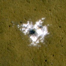
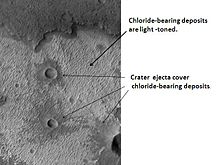
Chloride deposits
Chloride deposits in Terra Sirenum
Using data from Mars Global Surveyor, Mars Odyssey and the Mars
Reconnaissance Orbiter, scientists have found widespread deposits of
chloride minerals. Evidence suggests that the deposits were formed from
the evaporation of mineral enriched waters. The research suggests that
lakes may have been scattered over large areas of the Martian surface.
Usually chlorides are the last minerals to come out of solution.
Carbonates, sulfates, and silica should precipitate out ahead of them.
Sulfates and silica have been found by the Mars Rovers on the surface.
Places with chloride minerals may have once held various life forms.
Furthermore, such areas could preserve traces of ancient life.
Other aqueous minerals
In 2009, a group of scientists from the CRISM team reported on 9 to
10 different classes of minerals formed in the presence of water.
Different types of clays
(also called phyllosilicates) were found in many locations. The
physilicates identified included aluminum smectite, iron/magnesium
smectite, kaolinite, prehnite, and chlorite. Rocks containing carbonate were found around the Isidis basin. Carbonates belong to one class in which life could have developed. Areas around Valles Marineris were found to contain hydrated silica and hydrated sulfates. The researchers identified hydrated sulfates and ferric minerals in Terra Meridiani and in Valles Marineris. Other minerals found on Mars were jarosite, alunite, hematite, opal, and gypsum. Two to five of the mineral classes were formed with the right pH and sufficient water to permit life to grow.


0 comments:
Post a Comment